Earthworks Elevations Command
Description:
This command creates a volume surface and COGO points for cut/fill depths. It is used for platforms where the points must have a different color based on the cut or fill condition.
Location on Compact Ribbon:
Location on Extended Ribbon:
Instructions:
Before using this command, create a polyline which defines the boundary for the point creation. You can either draw this boundary or you can make a copy of the platform feature line, explode it once and convert to a 2D polyline, see the detailed steps below:
-
Select the platform feature line in plan, right-click and select the Copy to Site command from the menu:
-
For the Destination Site use <None> to avoid any interactivity with the other objects:
-
Explode the copied feature line once to convert it to a 3D polyline, convert the 3D polyline to a 2D polyline using the Grading – Polyline Utilities – Convert 3D to 2D Polylines command:
-
When the polyline is ready, run the command to open Earthworks Elevations dialog:
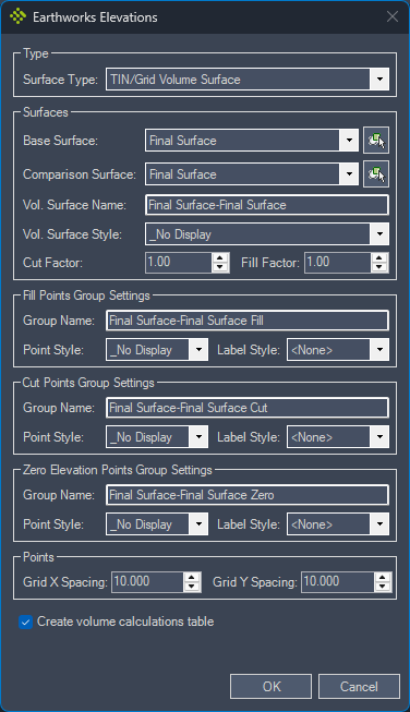 Note: Self-explanatory settings are not described below.
Surface Type: TIN/Grid Volume Surface creates a new volume surface which will be used to calculate the cut/fill depths for COGO points.
TIN/Grid Surface allows to use of a platform surface (or any other surface) to display the COGO points elevations.
Base Surface: surface used as the base surface for a volume surface.
Comparison Surface: surface used as the comparison surface for a volume surface.
Zero Elevation Point Group Settings: COGO points with a zero elevation do not fit into the cut or fill point groups therefore they are placed into this group.
Create Volume Calculation Table: tick this option if you want to create a static volume table. This table can be created at a later stage using the Volume Table Command.
-
Select the polyline defining the platform:
If you get the message shown in the image below, it means a point number is already used in the drawing. Click OK or hit Enter. This message will pop-up for each duplicate point number:
-
If you ticked the option to create a volume surface table, the table settings appear on the screen:
-
Specify the volume table location:
Created points:
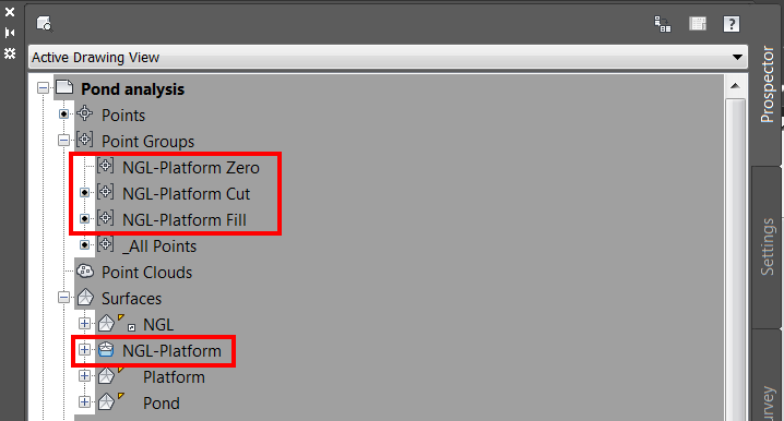
Created point groups and volume surface:
Created table:
